
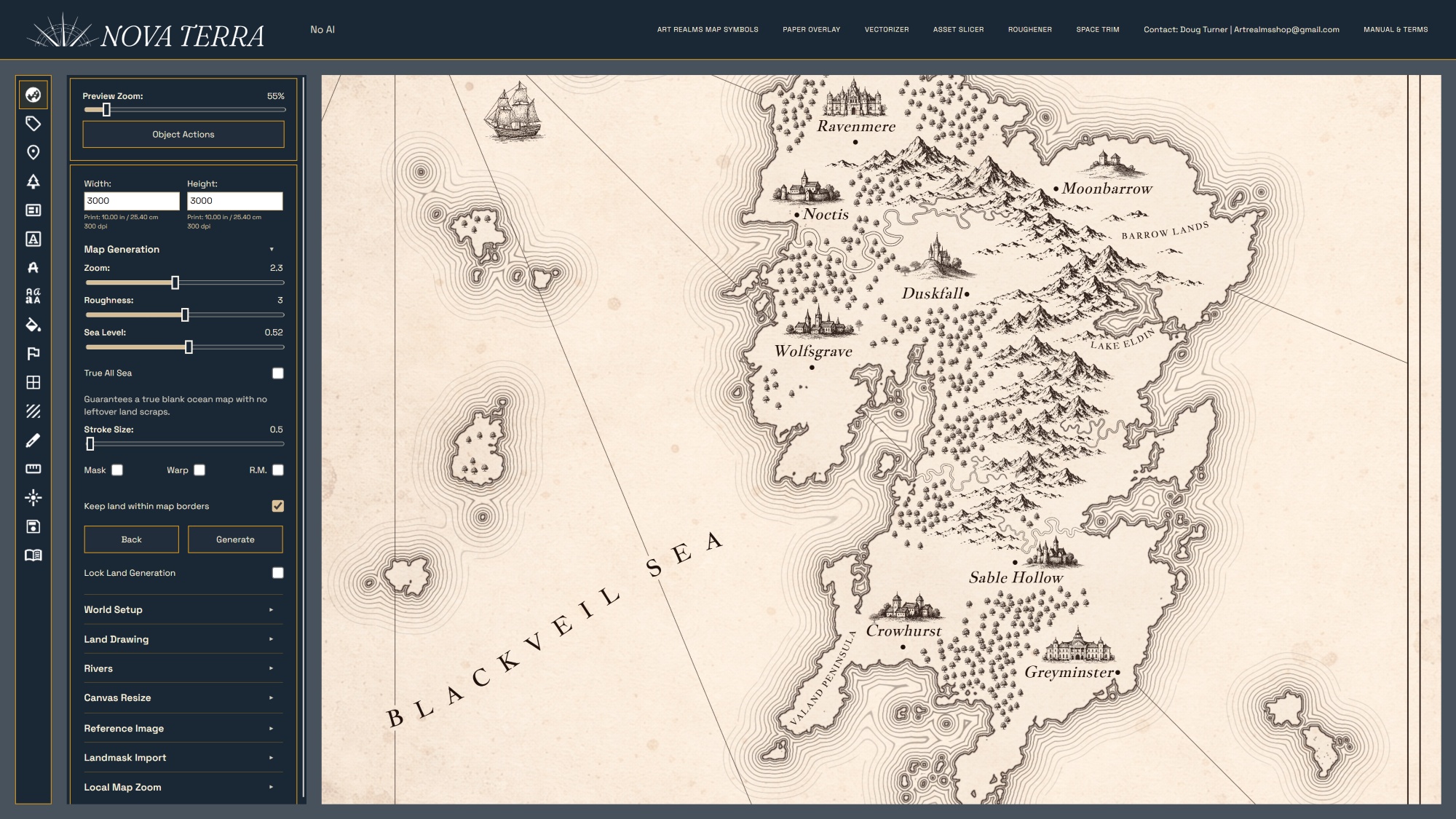
When you are building a world, your map should not just be a static image. It should be a living foundation for your stories, settings, and journeys. Nova Terra combines intuitive, web-based cartography tools with deep worldbuilding functionality to let you design professional, publication-ready maps of any kind, real or fantasy, entirely in your browser.
Whether you are a novelist plotting a fantasy book layout, a tabletop RPG game master designing custom regional campaign settings, or an independent worldbuilder creating intricate fictional atlases, this complete feature guide outlines every tool, generator, and asset library included in the full version of Nova Terra.
1. Procedural Landmass & Coastline Generation
Skip the frustration of staring at a blank canvas. Nova Terra includes advanced, flexible procedural generation tools to let you shape realistic continents and coastlines in seconds.
Algorithmic Landmass Controls
Automatically generate organic, hyper-realistic continental outlines, archipelagos, or land bridges with adjustable noise and fractal complexity.
Manual Coastline Sculpting
Add or subtract land instantly using intuitive brush tools to carve out specific bays, peninsulas, and inland seas.
Climate & Height Biases
Adjust procedural sliders to shift continental shapes based on climate variables, creating steep, jagged coastlines or low-lying coastal plains.
Black-and-White Mask Uploads
Already have a rough sketch? Upload a simple high-contrast image mask to instantly convert your custom shapes into clean, editable vector coastlines inside the engine.
2. Interactive Route, Scale, and Travel-Time Tracking
A great fantasy map should calculate the physical realities of your world's journeys. Nova Terra features dedicated transit engines that do the math for you.
Vector Route Tracing
Draw custom roads, maritime shipping lanes, mountain passes, and winding character paths directly onto the canvas.
Automated Distance Calculations
Set your map's scale in miles or kilometers, and the engine will instantly calculate the exact distance of any path you plot.
Custom Pacing & Transit Settings
Input custom travel speeds based on terrain types or transportation methods, including walking, horse travel, sailing ship routes, or marching armies.
Dynamic Travel Time Displays
Keep track of the precise days or hours required to travel between settlements, making it easy to maintain continuity in novels or tabletop campaigns.
3. High-Detail Asset Library (1,200+ Premium Map Symbols)
No need to buy separate digital asset packs. The full version of Nova Terra comes pre-loaded with a massive collection of hand-drawn, high-resolution PNG graphics to populate your world.
Multi-Biome Landscapes
Drop in realistic, high-detail mountain ranges, jagged peaks, mesa formations, rolling hills, volcanic structures, and craters.
Diverse Flora & Forests
Paint down expansive woodland regions using specific tree species, including dense pines, varied tropical palms, ancient hardwoods, and dead forests.
Global Architectural Styles
Customize settlements with castles, fortified keep gates, coastal lighthouses, stepped pyramids, regional villages, and historical ruins from across the globe.
Creatures & Combat Tokens
Illustrate world dangers by placing legendary fantasy monsters, local wildlife, land or sea beasts, and specialized army fighters directly onto the terrain.
4. Advanced Cartography Aesthetics & Rendering Styles
Shift your map's visual style seamlessly without losing a single settlement, label, or road layout. Nova Terra treats style as a separate, adjustable layer.
Vibrant Full-Color Mode
Render your world map using rich watercolor textures, vibrant terrain shading, and distinct regional colors.
Classic Book-Ready Line Art
Instantly strip away color to convert your map into a crisp, high-contrast, black-and-white vector atlas for print novels and monochrome book formatting.
Parchment & Paper Textures
Apply authentic, archival paper overlays, aged ink bleeds, and grit textures to give your digital canvas a hand-drawn look.
Adjustable Line Weights & Grayscale
Fine-tune outline thicknesses, drop shadows, and grayscale fills to ensure every symbol pops clearly against your background canvas.
5. Settlement Ledgers & Worldbuilding Databases
Manage your lore right where it happens. Nova Terra integrates metadata features so you can track populations, factions, and campaign notes directly behind the canvas interface.
Interactive Lore Ledgers
Right-click any city, town, dungeon, or custom landmark to pull up a dedicated text ledger.
Population & Resource Tracking
Log settlement statistics, ruling factions, regional resources, and active campaign hooks directly inside the map file.
Custom Map Labels & Hierarchy
Place text using custom fonts, curved text paths, and adjustable size hierarchies to separate massive kingdoms from tiny local villages.
6. Localized Regional Cropping & Scaling
Never lose structural context when shifting from a massive world map down to a tight, local adventuring zone.
Raw Editable Data Architecture
Nova Terra saves your project as raw data rather than a flat image grid.
Seamless Regional Cropping
Select any specific chunk of your global continental map and crop it into an independent, standalone project file.
High-Detail Scaling
Upscale the cropped region to add a hyper-detailed layer of local towns, roads, and topography while preserving the broader geographical positions of the main world map.
7. Professional, Print-Ready Exports
Your finished world maps are optimized for crisp physical printing, digital screen sharing, and seamless publishing layouts.
High-Resolution PNG Output
Export your map configurations into massive, uncompressed PNG files.
Zero Loss Formatting
High-contrast line art settings export perfectly at sharp print dimensions, eliminating fuzzy ink bleeds or blurry borders in self-published or traditionally published novels.
JSON Project Portability
Save, back up, and load your raw JSON files locally. Enjoy complete ownership over your world data with zero mandatory cloud lock-ins or subscription paywalls.