
For an author, a map is more than a piece of decorative art tucked into the front matter of a book. It is a structural framework for your plot. Your characters need to walk from the capital city to the eastern border, and your readers will notice if a journey that should take a month inexplicably happens over a weekend.
But traditional image editors make story mapping incredibly frustrating. If you alter a character's route during your second draft, you usually have to open an art program, erase flat layers, reposition text, and re-export a dead image from scratch.
Nova Terra solves this by replacing flat canvas drawing with a live, editable project workspace. It treats your map as an active manuscript companion, keeping your geography open to revision as your story takes shape.
The Real Danger of Locking Your Geography Too Early
When you are writing a first draft, your world is fluid. You discover new settings, cut redundant towns, and adjust distances on the fly. If you use a rigid map creator, you end up locking yourself into geography choices too early just to avoid the headache of redrawing everything.
Nova Terra keeps every layer independent. If a plot twist in Chapter 5 requires a river to block an army's advance, you can select your river vector, add a natural bend, and shift the surrounding forests dynamically. You don't have to choose between a cohesive story and an accurate map.
A Fluid Mapping Workflow for Writers
Nova Terra structures your mapping process so it mirrors the natural progression of writing a book:
1. Draft the Outline
Start by establishing your broad continental layout. Use procedural generation sliders to experiment with landmass silhouettes, or trace directly over a rough napkin sketch using the reference overlay tool. You only need to lock down the massive geographic features, like mountain walls and oceans, that define your world's political boundaries.
2. Plot the Journey
As your characters travel, drop in your settlements and roads. Because routes and paths in Nova Terra are fully editable vectors, you can drag, re-route, and adjust lines as your narrative pacing shifts. If you need realistic names for rival kingdoms or distant outposts, use the culture-based naming engines to quickly seed ideas without breaking your writing flow.
3. Log the Lore Right on the Canvas
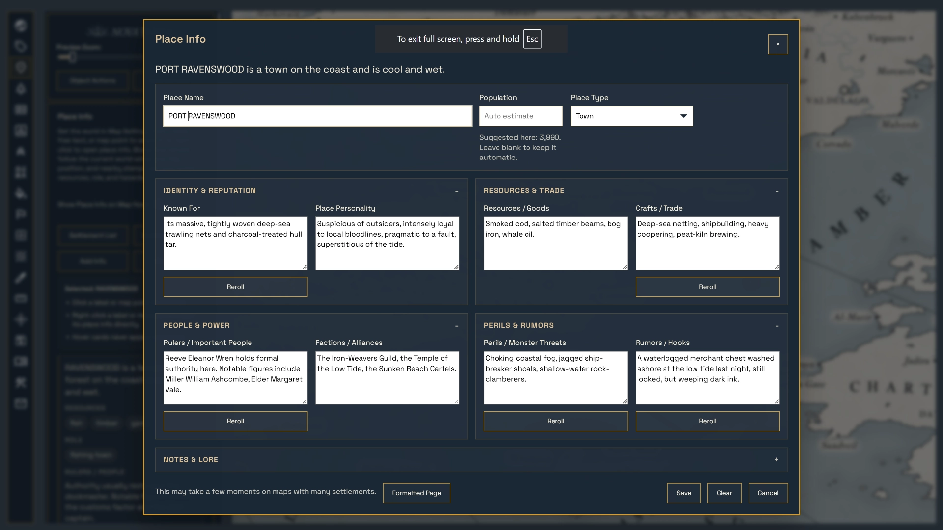
Instead of jumping back and forth between a separate world-building document and your map, you can store your world details directly inside the project file. Right-clicking any settlement or landmark opens a detailed Place Info card. Here, you can log population sizes, ruling factions, regional exports, and lore notes. It turns your map into an interactive gazetteer that acts as a single source of truth for your world's continuity.
Perfect Story Timeline Syncing
The core engine of Nova Terra is scale-aware, making it a powerful tool for calculating a book's timeline. Once you type in your global map span, the program embeds that scale directly into the map logic.
Using the path measurement tool, you can trace the exact winding road your characters take through a mountain pass. The travel-time calculator will evaluate the path and tell you exactly how long the trek will take based on their method of travel, whether they are marching on foot through muddy wetlands or riding horses down a paved highway. This ensures that your pacing, your calendar, and your geography stay in lockstep across every single chapter.
Ready for Print and Publication
When your manuscript is finished and it is time to prepare your map for publication, Nova Terra gives you complete stylistic control over the final output. You can apply a beautiful, hand-drawn atlas look using over 1,100 high-resolution cartographic symbols. Adjust ink colors, add decorative title blocks, choose classic paper textures, and tweak your borders until it looks like an authentic historical map.
When you are ready to send it to an editor or formatting specialist, Nova Terra lets you run a double-resolution export to generate clean, high-contrast, print-ready PNG files that look crisp on both physical paper and e-readers.